


autrans(Le truc)-charande

maupassant38
User
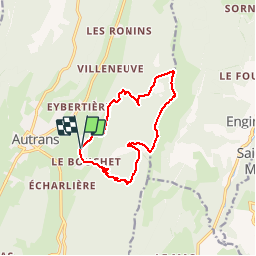

Length
11.9 km

Max alt
1712 m

Uphill gradient
661 m
Km-Effort
21 km

Min alt
1097 m

Downhill gradient
662 m
Boucle
Yes
Creation date :
2019-02-22 22:31:15.24
Updated on :
2019-02-22 22:31:15.253
3h25
Difficulty : Medium

FREE GPS app for hiking
 SityTrail
IGN / Geographical institutes
SityTrail Plus
The world is yours!
About
Trail Walking of 11.9 km to be discovered at Auvergne-Rhône-Alpes, Isère, Autrans-Méaudre en Vercors. This trail is proposed by maupassant38.
Positioning
Country:
France
Region :
Auvergne-Rhône-Alpes
Department/Province :
Isère
Municipality :
Autrans-Méaudre en Vercors
Location:
Autrans
Start:(Dec)
Start:(UTM)
701172 ; 5005446 (31T) N.
Comments